| Hurricane Isabel |
We sailed north for 1,200 miles from St Marten in the Caribbean to the
Chesapeake Bay, USA, where “hurricanes hardly happen”, to be
thumped by Isabel, a once in twenty five year phenomena. In our year
of living on Moonshine, our sturdy Westerly Corsair, we’ve
experienced an Atlantic Crossing, two gales, a storm, lots of lightning,
and a hurricane.
Our departure from Puerto Rico was hastened when Topical Storm Ana
came six weeks early, in April. All the way north through the British
and US Virgins, and the Bahamas we had muttered, “June too soon.
July standby. August you must. September remember. October all
over.” We motor sailed up the ICW from West Palm Beach to Norfolk
and into the Chesapeake Bay. In July we’d stood fast as the remnants
of Tropical Storm Claudette bashed about us. At the beginning of
September we took shelter in a lightening storm in Solomons Island,
Maryland, one hour south of Washingon D.C. We had anticipated
completing our end of first year sort-out-fix-it in Annapolis, three days
sail away. We found the Solomons suited all our needs, and was
cheaper. One week after our arrival on 7th September tropical storm
Isabel grew to hurricane strength. By the 11th she was a category five
with 155 mile an hour winds.
Sunday 14th September: Hurricane Isabel was north of the Bahamas
heading towards us in the U.S.. She was still category five but,
weakening. We were amazed. Isabel was forecast to track above the
usual points of landfall such as the Bahamas, Florida and South
Carolina, to hit Moonshine in Maryland on Thursday 18th September in
the afternoon. Wednesday we were flying home for a visit, not.
Moonshine was to have been berthed in the Hospitality Harbour whilst
we visited the UK.
Three anchors in a protected area? Versus secured in a spider web of
lines on a dock? Would the anchors hold? How to configure the lines?
Would we be able to stay? We knew of one marina in the south which
ordered all boats out during hurricanes. In February St Margarets
doubled Moonshine’s insurance premium and reduced the cover, no
longer insuring against damage caused by named storms even if we
were out of the designated hurricane belt, (north of Cape Hatteras,
North Carolina and south of Grenada). Searches for alternatives offered
no better for new clients.
Monday 15th September: Isabel had reduced speed to category four.
With a $200 fee to change each ticket, I argued with British Airways
that we, Brits, were not “choosing” , but, being forced to change our
flights because our home was in danger. My “special circumstances”
was met by supervisors quoting “policy. We decided to wait until
Tuesday for a BA thaw. The genoa, the main and the sail bag were
removed. Most of D dock were in “denial“. Dave on Island Girl changed
the oil.
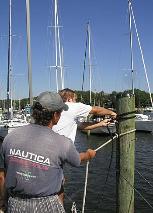
Tuesday 16th September: John walked the dock and made the first
attempt on the spider’s web of lines which would be Moonshine’s
safety net. Fighter jets flew out of the Naval Air Warfare Centre
(NAWCAD) five miles away, to airbases out of Isabel’s path. Ships in
the US naval fleet sailed out from Norfolk, Virginia, to the safety of the
Atlantic ocean. British Airways relaxed their policy for those flying on
Thursday and Friday. But, it was no way from BA for us. Spitting we
paid out the $200 each.
The tensions grew. Our usually healthy appetites died. Diet coke kept
us going. Bill Glascock has owned the Hospitality marina, our chosen
Hurricane hole , for seventeen years. Isobel was his first hurricane.
Whilst fielding anxious questions he emptied his floating, wooden
office of electrical equipment and placed giant fenders between it and
the dock. Greg von Ziclinski and Bill had been friends since high
school. Greg lives aboard a lifeboat from a naval warship, converted for
his “ocean ministry“, “2God.org”. I nick named him Spiderman. Greg
used to import yachts. His knowledge and advice on knots and spider
web strategy were invaluable.
The dock was full of discussions on the weather channel’s latest and
the perfect cats cradle. Trawlers, motor boats and yacht skippers
compared knots. The clove hitch with two half hitches was deemed
best. If it wasn’t knots it was second guessing the height of the surge,
the seawater which the strong winds would pile up ashore. If the lines
were not tied tightly enough at the top of the pilings the surge could
float the boat off free to smash itself on pilings and neighbours. One
of the empty berths next to us belonged to “Best Pals.” Like numerous
keel-less motor boats it had been lifted out then, blocked one foot off
the ground about two hundred yards inland. Another power boater
wondered if a flimsy tarpaulin would help keep his seats dry. He
wrapped his four puny lines, cracked open a beer and lumbered off.
Perhaps, clueless was better than the gnawing threat we felt. Perhaps
not.
John spent the night following Isabel’s relentless flight on the NOAA,
(National Oceanic graphic and Atmospheric Administration) website
and researching the best spiderweb configuration. Across the dock
Island Girl, a Cape Dory 37 were strung out. The boat is Dave and Cindy
Foss’s only home. After seven years of planning they set out in July
from Michigan, in the northern US. Dave’s mother-in-law was dead
against cruising. Her name? Isabel.
The joke went round that the Floridians had put out huge fans to blow
Isabel north. It was working. Again, we chewed over whether to stay
on the dock or head for a creek. Local knowledge suggested St
Leonard’s Creek where the high sides gave good protection. The
berths either side of Moonshine were free. We gave black looks to
those entering the D dock channel. In the adjacent, Spring Cove
Marina the boats were crammed in.
As with the discussions on spider webs, so with the anchor debates.
Danforths were considered best for the mud of the Chesapeake. Some
dismissed the Bahamian moor V formation because the boat can twist
in the wind, winding the two chains around each other. If one knew
the wind direction, two anchors on the same side could pull against it,
however, this is risky as the final track of the hurricane is
unpredictable. The triangle method was considered best. Whether at
anchor or on a dock everyone viewed other people’s boats as
potential liabilities. In their mid twenties Dan and Carol on Alona, an
ancient trawler, had been anchored in St Leonard’s Creek for two days
when older cruisers set their one (!) anchor over Alona’s anchor line,
and refused to move it. Alona were forced to re-set. Eighty three year
old Captain Seaweed (think Ben Gun) plumbed the depth of the
furthest end of Cuckold Creek. Using a triangular configuration of
three anchors he wedged his steel boat with its four foot draft into a
nook. He had a fourth anchor spare in case. Solomons Island is on the
Patuxent River along which there are dozens of creeks offering
hurricane holes. Trooper, a Hillyard 37 were unsure about the dock
they were offered in Mill Creek. They dropped a lead line and
discovered a Hillyard 37 size hurricane hole. Three anchors and a web
of twenty lines, some over one hundred feet long reaching to the dock
and surrounding trees, ensured that the only movement could be six
inches down into the mud below. In June in Pipeline Canal near
Southport, North Carolina, during a vicious lightning storm, we
dragged, for the first time, onto a beach and bent our CQR. It knocked
our confidence and swayed our decision to stay on the dock.
Wednesday 17th. The “fear of the unknown” gripped dock masters and
cruisers. Isabel was now category two with winds of 110mph at the
eye wall. Sleep was fitful and disturbing. Two am John could not sleep.
The thumping noises on the cabin roof turned out to be John taking
the barbecue and the life raft off the stern railings and the wind
generator from the gantry, removing all items that added windage.
The bimini was dismantled. The spray hood strapped down. Even the
pegs from the clothes line. The fishing rods, boat hook, brush and
danboy were stored in the forward cabin with the bimini canvas, sail
bag and sails. The mainsail battens lay on the salon sole. The outboard
motor, horse shoe life preserver, empty jerry cans for water and fuel
joined the wind vane in Moonshine’s cavernous cockpit locker.
Fenders were hung around Moonshine’s bow and aft. The governors of
North Carolina, Virginia, Maryland and Delaware declared states of
emergency and mobilized the national guard. West Marine and other
shops were boarded up.
Still no one came to secure the 40 foot Beneteau next to us. Bill and
Greg worked tirelessly securing boats abandoned by their owners. It
seemed surreal to see them tying a rope rail lifeline along the walkway
on a sunny day with blue cloudless skies. Moonshine sat in her web:
sixteen 5/8th of an inch dock lines attached to eleven pilings; her 45lb
CQR set on chain just off her bow and her spare anchor rode wrapped
around the windlass then, tied off 100 feet away to a pile on the other
side of the channel. Would the cleats hold? The preparations kept the
stress at bay. John extended the web around the Beneteau. The
owner’s dockside tub of roses was lugged into the Beneteau’s cockpit.
The intention to stay onboard Moonshine during the storm seemed
foolhardy, a room, in the hotel overlooking the boats was the answer.
We cut the cost by sharing with Island Girl.
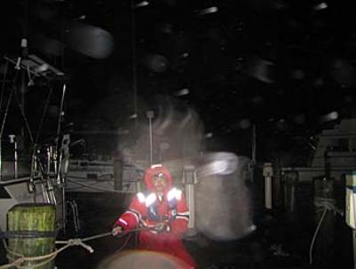
Thursday 19th. At five am we tied Moonbeam, the dinghy, on a
diagonal between two piles. If she was blown anywhere it would be
into the mud around the edge of the mini cove. The sky was grey.
High tide at 9am did not go down. Grim predictions filled the paper.
The batteries to power the bilges were charged by running the
engine. US boats detached the shore power. The lines from the
windlass stretched across the channel were raised thereby allowing
skippers to haul their boats away from dock. No more boats could
enter C or D docks. It was blustery and spitting. We checked into the
hotel with a marina cart full of waterproofs, torches, cameras, laptops,
picnics, and our most important possessions. The weather channel
remained on until the power failed later that night.
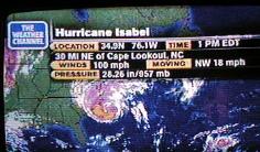
Isabel made land fall in Kill Devil Hills, North Carolina at 11am. (See
photograph of television coverage.) Cars were turned upside down in
the nine foot storm surge. The Outer Banks and North Carolina coast
took the full force. Houses were swamped and some washed away in
nearby Kitty Hawk. It was estimated that 300,000 were without power
in Virginia Beach. We thought of our friends in Belhaven North
Carolina, where the waters from Pamlico Sound, just inside the Outer
Banks would flood the town, just as it did during Floyd in 1999. Floyd
hit less populated areas after a drought. Isabel was aiming for
metropolitan areas such as Norfolk, Annapolis, Washington DC and
Baltimore after a rainy summer.
We experienced the first effects of the bands (or spirals) of the
system along the Patuxent River at 5 pm. Isabel’s now increasing
speed meant there was less rain fall. The water had risen four feet and
lapped at the base of the finger pontoons, just under the walkway.
John and the other skippers raised the lines even further up the
pilings. By the time the winds reached Solomons Island they were
down to a mere sustained 40 knots with gusts of storm force 11, not
the estimated 74 knots, hurricane strength. By the 7.30pm the winds
lulled. This gave us a false sense of security. We thought we’d got
away with it. Replete from the our Chinese take away we watched the
boats from our fifth floor hotel room. Suddenly Dave’s cap was blown
across the room. 9.30pm The winds had returned with a vengeance -
up by 20 knots. We were now in the north east quadrant (or RFQ, right
front quadrant) where the winds are at their highest, and the surge
highest. All hell broke loose. We hadn’t got away with it at all. The
eye wall was coming.
On the fifth floor the windows shook. Huge trees arched and crashed.
Below the masts tilted at an acute angle. The rigging screamed. We
recalled our first days out in the Atlantic, two hundred miles off
shore, in a 40 knot storm with gusts of 55. At least this time we were
up a dog leg, at the back of Back Creek, protected by trees and a large
hotel. Back into his soggy waterproofs John found a far more menacing
situation. The extra twenty knots felt like forty. With the darkness
and rain obscuring their vision the skippers used the rope rail along
the walkway to pull themselves against the wind, through the waves
washing over the dock which was now two feet deep under water.
Strangely it was 70 degrees, quite warm. There were several
explosions and flashes in the distance. The sky turned green. The
town’s power transponders had blown. The boat’s lines on D dock
were secure. It was way too hazardous for any more changes to be
made. Reluctant and feeling helpless in the face of such severe
conditions John and Dave returned to the hotel warning other
skippers not to go out.
Isabel stomped north to Annapolis at the top of the Chesapeake Bay
causing extensive flooding and wind damage.
Friday 19th September: 4.00am The winds were abating. The dock was
still two feet under water. Nonetheless all was well in Hospitality
Harbour. Our new D-dock family had survived remarkably intact.
8am It was a beautiful morning with clear blue skies, and hardly a
breath of wind. We sloshed along the dock. Moonshine floated above
us. We motored with the “vicar”, Greg, a mile down Back Creek to the
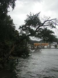
opening into the Patuxent River where the damage was heaviest. The
front line of onslaught from Isabel left pilings stripped of their
walkways and docks broken up. The bow sprit of a Cabo Roca had
been smashed against its pilings. The port side hull of a Swan 42 was
splintered and completely separated at the hull deck join. A chilling
site. Shredded sails flapped in the light breeze.
In Spring Cove Marina, the marina next to us, a boom had torn through
a bimini. Their Autumn Newsletter seemed ironic, “If everyone is
prepared, I’m sure the hurricane will miss!” The power was still out.
The marina shop fridge was de-frosting. Cruisers slurped free, melting
ice cream. Several metal strips in the roof of the large boat ‘garage”
had been ripped up. Nails in the sheet had gouged holes in a sleek
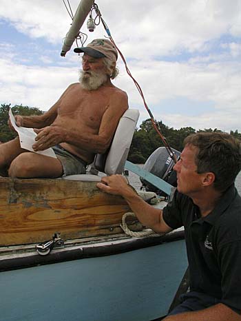
motor boats gel coat. Captain Seaweed motored past, wrinkled and
toothless, as ever, his sixth hurricane under his keel with no ill
effects. Alona were re-anchored near the picturesque Drum Point
Lighthouse, Dan and Carol were re-attaching their makeshift red check
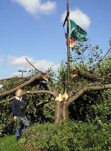
tablecloth-awning. In St Leonard’s Creek a massive oak had fallen
towards Alona … it had landed on her lines.
By 4pm the water was under the dock. Bill re-activated the power. Air
conditioning flowed into the trawlers. We were able to climb up to
Moonshine, still high in the water. It was good to be back on our home.
The Beneteau’s owner never showed. The rose bush was a bit the
worse for hurricane wear. The reparations took a day, much faster
than the fearful preparations. The D dockers celebrated with Bill and
Greg in Solomons Island Yacht Club, before a D-Day barbecue.
Island Girl is going to make it to the Islands. We’re now ready for fair
winds as we head south to the Bahamas, Cuba, the Caribbean and the
San Blas.
Text copyright Nicola Rodriguez Oct 2003
Photographs copyright John & Nicola Rodriguez Oct 2003
Chesapeake Bay, USA, where “hurricanes hardly happen”, to be
thumped by Isabel, a once in twenty five year phenomena. In our year
of living on Moonshine, our sturdy Westerly Corsair, we’ve
experienced an Atlantic Crossing, two gales, a storm, lots of lightning,
and a hurricane.
Our departure from Puerto Rico was hastened when Topical Storm Ana
came six weeks early, in April. All the way north through the British
and US Virgins, and the Bahamas we had muttered, “June too soon.
July standby. August you must. September remember. October all
over.” We motor sailed up the ICW from West Palm Beach to Norfolk
and into the Chesapeake Bay. In July we’d stood fast as the remnants
of Tropical Storm Claudette bashed about us. At the beginning of
September we took shelter in a lightening storm in Solomons Island,
Maryland, one hour south of Washingon D.C. We had anticipated
completing our end of first year sort-out-fix-it in Annapolis, three days
sail away. We found the Solomons suited all our needs, and was
cheaper. One week after our arrival on 7th September tropical storm
Isabel grew to hurricane strength. By the 11th she was a category five
with 155 mile an hour winds.
Sunday 14th September: Hurricane Isabel was north of the Bahamas
heading towards us in the U.S.. She was still category five but,
weakening. We were amazed. Isabel was forecast to track above the
usual points of landfall such as the Bahamas, Florida and South
Carolina, to hit Moonshine in Maryland on Thursday 18th September in
the afternoon. Wednesday we were flying home for a visit, not.
Moonshine was to have been berthed in the Hospitality Harbour whilst
we visited the UK.
Three anchors in a protected area? Versus secured in a spider web of
lines on a dock? Would the anchors hold? How to configure the lines?
Would we be able to stay? We knew of one marina in the south which
ordered all boats out during hurricanes. In February St Margarets
doubled Moonshine’s insurance premium and reduced the cover, no
longer insuring against damage caused by named storms even if we
were out of the designated hurricane belt, (north of Cape Hatteras,
North Carolina and south of Grenada). Searches for alternatives offered
no better for new clients.
Monday 15th September: Isabel had reduced speed to category four.
With a $200 fee to change each ticket, I argued with British Airways
that we, Brits, were not “choosing” , but, being forced to change our
flights because our home was in danger. My “special circumstances”
was met by supervisors quoting “policy. We decided to wait until
Tuesday for a BA thaw. The genoa, the main and the sail bag were
removed. Most of D dock were in “denial“. Dave on Island Girl changed
the oil.
Tuesday 16th September: John walked the dock and made the first
attempt on the spider’s web of lines which would be Moonshine’s
safety net. Fighter jets flew out of the Naval Air Warfare Centre
(NAWCAD) five miles away, to airbases out of Isabel’s path. Ships in
the US naval fleet sailed out from Norfolk, Virginia, to the safety of the
Atlantic ocean. British Airways relaxed their policy for those flying on
Thursday and Friday. But, it was no way from BA for us. Spitting we
paid out the $200 each.
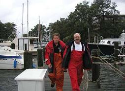
The tensions grew. Our usually healthy appetites died. Diet coke kept
us going. Bill Glascock has owned the Hospitality marina, our chosen
Hurricane hole , for seventeen years. Isobel was his first hurricane.
Whilst fielding anxious questions he emptied his floating, wooden
office of electrical equipment and placed giant fenders between it and
the dock. Greg von Ziclinski and Bill had been friends since high
school. Greg lives aboard a lifeboat from a naval warship, converted for
his “ocean ministry“, “2God.org”. I nick named him Spiderman. Greg
used to import yachts. His knowledge and advice on knots and spider
web strategy were invaluable.
The dock was full of discussions on the weather channel’s latest and
the perfect cats cradle. Trawlers, motor boats and yacht skippers
compared knots. The clove hitch with two half hitches was deemed
best. If it wasn’t knots it was second guessing the height of the surge,
the seawater which the strong winds would pile up ashore. If the lines
were not tied tightly enough at the top of the pilings the surge could
float the boat off free to smash itself on pilings and neighbours. One
of the empty berths next to us belonged to “Best Pals.” Like numerous
keel-less motor boats it had been lifted out then, blocked one foot off
the ground about two hundred yards inland. Another power boater
wondered if a flimsy tarpaulin would help keep his seats dry. He
wrapped his four puny lines, cracked open a beer and lumbered off.
Perhaps, clueless was better than the gnawing threat we felt. Perhaps
not.
John spent the night following Isabel’s relentless flight on the NOAA,
(National Oceanic graphic and Atmospheric Administration) website
and researching the best spiderweb configuration. Across the dock
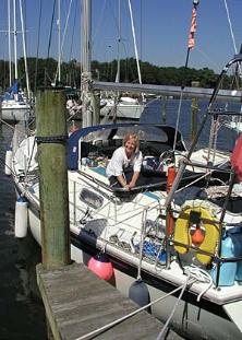
Island Girl, a Cape Dory 37 were strung out. The boat is Dave and Cindy
Foss’s only home. After seven years of planning they set out in July
from Michigan, in the northern US. Dave’s mother-in-law was dead
against cruising. Her name? Isabel.
The joke went round that the Floridians had put out huge fans to blow
Isabel north. It was working. Again, we chewed over whether to stay
on the dock or head for a creek. Local knowledge suggested St
Leonard’s Creek where the high sides gave good protection. The
berths either side of Moonshine were free. We gave black looks to
those entering the D dock channel. In the adjacent, Spring Cove
Marina the boats were crammed in.
As with the discussions on spider webs, so with the anchor debates.
Danforths were considered best for the mud of the Chesapeake. Some
dismissed the Bahamian moor V formation because the boat can twist
in the wind, winding the two chains around each other. If one knew
the wind direction, two anchors on the same side could pull against it,
however, this is risky as the final track of the hurricane is
unpredictable. The triangle method was considered best. Whether at
anchor or on a dock everyone viewed other people’s boats as
potential liabilities. In their mid twenties Dan and Carol on Alona, an
ancient trawler, had been anchored in St Leonard’s Creek for two days
when older cruisers set their one (!) anchor over Alona’s anchor line,
and refused to move it. Alona were forced to re-set. Eighty three year
old Captain Seaweed (think Ben Gun) plumbed the depth of the
furthest end of Cuckold Creek. Using a triangular configuration of
three anchors he wedged his steel boat with its four foot draft into a
nook. He had a fourth anchor spare in case. Solomons Island is on the
Patuxent River along which there are dozens of creeks offering
hurricane holes. Trooper, a Hillyard 37 were unsure about the dock
they were offered in Mill Creek. They dropped a lead line and
discovered a Hillyard 37 size hurricane hole. Three anchors and a web
of twenty lines, some over one hundred feet long reaching to the dock
and surrounding trees, ensured that the only movement could be six
inches down into the mud below. In June in Pipeline Canal near
Southport, North Carolina, during a vicious lightning storm, we
dragged, for the first time, onto a beach and bent our CQR. It knocked
our confidence and swayed our decision to stay on the dock.
Wednesday 17th. The “fear of the unknown” gripped dock masters and
cruisers. Isabel was now category two with winds of 110mph at the
eye wall. Sleep was fitful and disturbing. Two am John could not sleep.
The thumping noises on the cabin roof turned out to be John taking
the barbecue and the life raft off the stern railings and the wind
generator from the gantry, removing all items that added windage.
The bimini was dismantled. The spray hood strapped down. Even the
pegs from the clothes line. The fishing rods, boat hook, brush and
danboy were stored in the forward cabin with the bimini canvas, sail
bag and sails. The mainsail battens lay on the salon sole. The outboard
motor, horse shoe life preserver, empty jerry cans for water and fuel
joined the wind vane in Moonshine’s cavernous cockpit locker.
Fenders were hung around Moonshine’s bow and aft. The governors of
North Carolina, Virginia, Maryland and Delaware declared states of
emergency and mobilized the national guard. West Marine and other
shops were boarded up.
Still no one came to secure the 40 foot Beneteau next to us. Bill and
Greg worked tirelessly securing boats abandoned by their owners. It
seemed surreal to see them tying a rope rail lifeline along the walkway
on a sunny day with blue cloudless skies. Moonshine sat in her web:
sixteen 5/8th of an inch dock lines attached to eleven pilings; her 45lb
CQR set on chain just off her bow and her spare anchor rode wrapped
around the windlass then, tied off 100 feet away to a pile on the other
side of the channel. Would the cleats hold? The preparations kept the
stress at bay. John extended the web around the Beneteau. The
owner’s dockside tub of roses was lugged into the Beneteau’s cockpit.
The intention to stay onboard Moonshine during the storm seemed
foolhardy, a room, in the hotel overlooking the boats was the answer.
We cut the cost by sharing with Island Girl.
Thursday 19th. At five am we tied Moonbeam, the dinghy, on a
diagonal between two piles. If she was blown anywhere it would be
into the mud around the edge of the mini cove. The sky was grey.
High tide at 9am did not go down. Grim predictions filled the paper.
The batteries to power the bilges were charged by running the
engine. US boats detached the shore power. The lines from the
windlass stretched across the channel were raised thereby allowing
skippers to haul their boats away from dock. No more boats could
enter C or D docks. It was blustery and spitting. We checked into the
hotel with a marina cart full of waterproofs, torches, cameras, laptops,
picnics, and our most important possessions. The weather channel
remained on until the power failed later that night.
Isabel made land fall in Kill Devil Hills, North Carolina at 11am. (See
photograph of television coverage.) Cars were turned upside down in
the nine foot storm surge. The Outer Banks and North Carolina coast
took the full force. Houses were swamped and some washed away in
nearby Kitty Hawk. It was estimated that 300,000 were without power
in Virginia Beach. We thought of our friends in Belhaven North
Carolina, where the waters from Pamlico Sound, just inside the Outer
Banks would flood the town, just as it did during Floyd in 1999. Floyd
hit less populated areas after a drought. Isabel was aiming for
metropolitan areas such as Norfolk, Annapolis, Washington DC and
Baltimore after a rainy summer.
We experienced the first effects of the bands (or spirals) of the
system along the Patuxent River at 5 pm. Isabel’s now increasing
speed meant there was less rain fall. The water had risen four feet and
lapped at the base of the finger pontoons, just under the walkway.
John and the other skippers raised the lines even further up the
pilings. By the time the winds reached Solomons Island they were
down to a mere sustained 40 knots with gusts of storm force 11, not
the estimated 74 knots, hurricane strength. By the 7.30pm the winds
lulled. This gave us a false sense of security. We thought we’d got
away with it. Replete from the our Chinese take away we watched the
boats from our fifth floor hotel room. Suddenly Dave’s cap was blown
across the room. 9.30pm The winds had returned with a vengeance -
up by 20 knots. We were now in the north east quadrant (or RFQ, right
front quadrant) where the winds are at their highest, and the surge
highest. All hell broke loose. We hadn’t got away with it at all. The
eye wall was coming.
On the fifth floor the windows shook. Huge trees arched and crashed.
Below the masts tilted at an acute angle. The rigging screamed. We
recalled our first days out in the Atlantic, two hundred miles off
shore, in a 40 knot storm with gusts of 55. At least this time we were
up a dog leg, at the back of Back Creek, protected by trees and a large
hotel. Back into his soggy waterproofs John found a far more menacing
situation. The extra twenty knots felt like forty. With the darkness
and rain obscuring their vision the skippers used the rope rail along
the walkway to pull themselves against the wind, through the waves
washing over the dock which was now two feet deep under water.
Strangely it was 70 degrees, quite warm. There were several
explosions and flashes in the distance. The sky turned green. The
town’s power transponders had blown. The boat’s lines on D dock
were secure. It was way too hazardous for any more changes to be
made. Reluctant and feeling helpless in the face of such severe
conditions John and Dave returned to the hotel warning other
skippers not to go out.
Isabel stomped north to Annapolis at the top of the Chesapeake Bay
causing extensive flooding and wind damage.
Friday 19th September: 4.00am The winds were abating. The dock was
still two feet under water. Nonetheless all was well in Hospitality
Harbour. Our new D-dock family had survived remarkably intact.
8am It was a beautiful morning with clear blue skies, and hardly a
breath of wind. We sloshed along the dock. Moonshine floated above
us. We motored with the “vicar”, Greg, a mile down Back Creek to the
opening into the Patuxent River where the damage was heaviest. The
front line of onslaught from Isabel left pilings stripped of their
walkways and docks broken up. The bow sprit of a Cabo Roca had
been smashed against its pilings. The port side hull of a Swan 42 was
splintered and completely separated at the hull deck join. A chilling
site. Shredded sails flapped in the light breeze.
In Spring Cove Marina, the marina next to us, a boom had torn through
a bimini. Their Autumn Newsletter seemed ironic, “If everyone is
prepared, I’m sure the hurricane will miss!” The power was still out.
The marina shop fridge was de-frosting. Cruisers slurped free, melting
ice cream. Several metal strips in the roof of the large boat ‘garage”
had been ripped up. Nails in the sheet had gouged holes in a sleek
motor boats gel coat. Captain Seaweed motored past, wrinkled and
toothless, as ever, his sixth hurricane under his keel with no ill
effects. Alona were re-anchored near the picturesque Drum Point
Lighthouse, Dan and Carol were re-attaching their makeshift red check
tablecloth-awning. In St Leonard’s Creek a massive oak had fallen
towards Alona … it had landed on her lines.
By 4pm the water was under the dock. Bill re-activated the power. Air
conditioning flowed into the trawlers. We were able to climb up to
Moonshine, still high in the water. It was good to be back on our home.
The Beneteau’s owner never showed. The rose bush was a bit the
worse for hurricane wear. The reparations took a day, much faster
than the fearful preparations. The D dockers celebrated with Bill and
Greg in Solomons Island Yacht Club, before a D-Day barbecue.
Island Girl is going to make it to the Islands. We’re now ready for fair
winds as we head south to the Bahamas, Cuba, the Caribbean and the
San Blas.
Text copyright Nicola Rodriguez Oct 2003
Photographs copyright John & Nicola Rodriguez Oct 2003